
Published 7:19 a.m. | Updated 3:15 p.m.
The second largest wildfire in Colorado history, the Spring Creek Fire, continues to grow between Costilla and Huerfano counties. On Thursday the blaze near La Veta Pass officially crawled over the 100,000-acre mark -- almost 150 square miles.
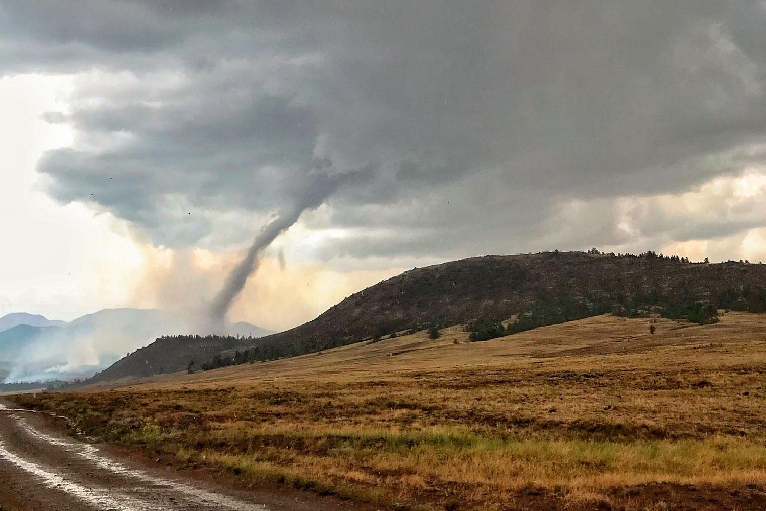
At the Weston Pass Fire north of Fairplay, a high-elevation tornado touched down briefly on Thursday. It apparently caused little damage and had no effect on the fire, but it caught the attention of meteorologists, as well as social media, because of its rarity.
Over in the Roaring Fork Valley between Glenwood Springs and Aspen, the erratic Lake Christine Fire charged through extremely dry land, destroying three homes while it forced people to flee, authorities said Thursday.
The three are among the largest and most active of 10 wildfires burning across the Centennial State. Like most of the West, dry conditions, whipping winds and increasing heat have made it easy for flames to spread.
In Basalt, more than 500 homes — multimillion-dollar properties, modest condos and mobile homes — were affected by evacuations. The Eagle County Sheriff's Department said no other homes had been lost besides the three reported earlier. In addition to the obvious disruptions to the towns of Basalt and El Jebel caused the by the fire, smoke also temporarily halted flights at Aspen's airport up the valley.
The Lake Christine Fire is currently 5,263 acres with no containment. Federal fire managers have assumed command and resources are working their way to the fire. Incident commander Mike Almus told The Aspen Times there will be between 300 and 400 firefighters by the weekend.
Gov. John Hickenlooper visited the Lake Christine Fire command post on Friday before heading south to the San Luis Valley to visit community members and emergency workers at the Spring Creek Fire near Fort Garland.
In Basalt, the governor admitted he was not aware that gun ranges poses such a fire risk before the Lake Christine incident. He vowed to make accessing ranges during periods of high fire risk as difficult as finding fireworks.
"If it is [easier], it won’t be. Let me just say that as a blanket statement," Hickenlooper said.
The governor said Colorado is in a better place now than it was in previous years, primarily because there's more firefighting training, supplies and crews than ever before.
"We have more resources active in this state right now than I think we’ve ever had in history," he said.
Spring Creek Fire crews made a significant amount of progress by the end of Thursday on the fire’s west, northernmost and east-southeast sides. The area was under a flash flood warning for the day and rain fell in Cuchara and La Veta with no word on how that helped efforts. The growth of the Spring Fire finally slowed some, adding 2,347 acres overnight. The fire stands at 105,704 acres — just over 165 square miles — with containment at 35 percent.
The #SpringCreekFire has burned more than 100,000 acres since it started 8 days ago, that's larger than all of Denver. The Forbes Park neighborhood was drastically affected as shown in this image from @DigitalGlobe collected on June 30, 2018. #SpringFire pic.twitter.com/gs2jguWDlY
The Colorado Department of Transportation plans to reopen US 160 between Fort Garland and La Veta on July 7 at 2 p.m. The highway had been closed since June 27 when flames started to overtake La Veta pass.
Other closures related to the Spring Fire will remain in effect. State Highway 69 will remain closed north of Walsenburg to the Huerfano-Custer county line. CO 12 is still closed from La Veta to the summit of Cuchara Pass. Up to date road information can be found at cotrip.org.