

Published 08.20.2018 | Updated 08.24.2018
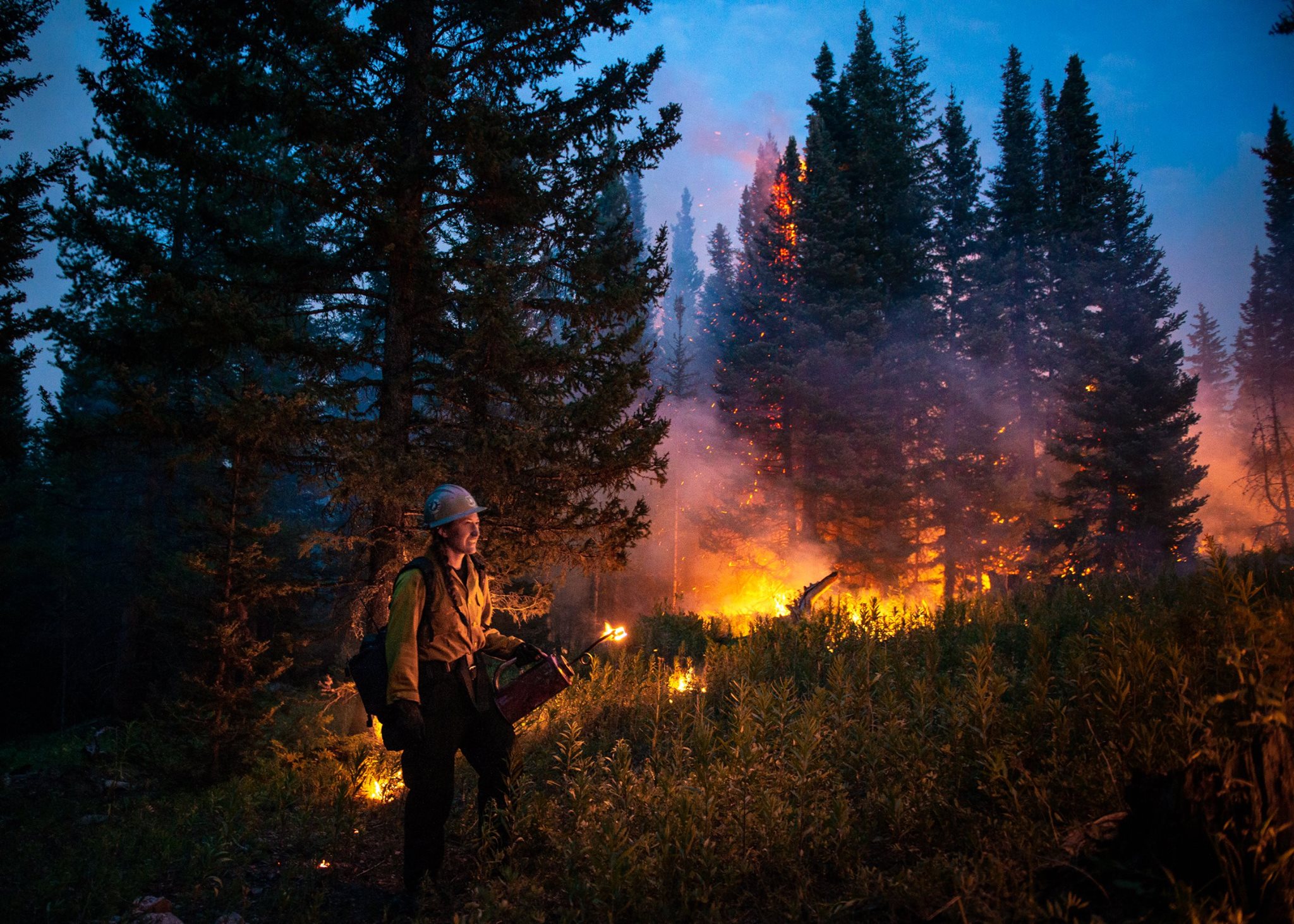
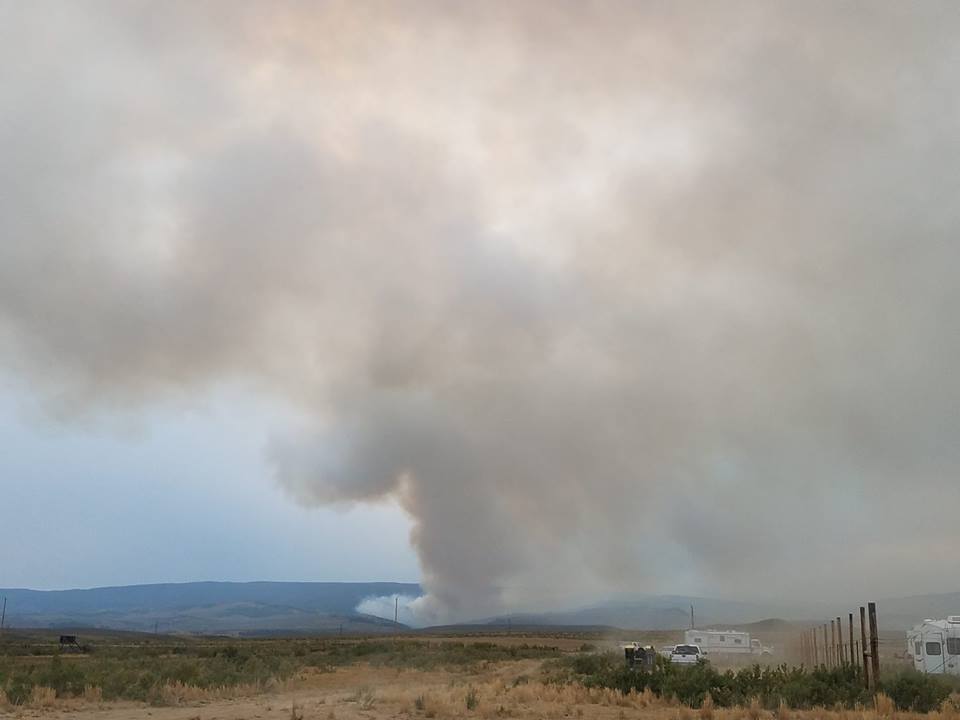
Wildfire smoke continues to hover over the Front Range and northwestern Colorado. State health officials issued another air quality advisory until Friday afternoon and poor visibility is expected for Denver. A Fine Particulate Action Day is in effect until 4 p.m. Thursday, meaning people with respiratory illnesses, the very young and elderly should remain indoors if the smoke is heavy.
Nine fires were active, according to Inciweb. Here are the latest updates on fires burning across Colorado:
Aug. 24 Updates
Bull Draw Fire Activity Remains Minimal
The fire had minimal activity by Friday morning after rain on Tuesday and Wednesday. But muddy roads made accessing the fire a challenge to firefighters, the Bull Draw Fire Facebook page reported. The blaze burned 30,208 acres and is 32 percent contained. More than 300 people were working on the fire.


Improved Firelines In Silver Creek Fire
Firefighters reached 27 percent containment in the Silver Creek Fire with 4,745 acres burned. Fire crews worked on the west side of the fire, removing possible fuels, where the Old Park subdivision is, the Silver Creek Fire Facebook page reported.
Downgraded Fire Restrictions In Cabin Lake Fire
Rio Blanco County will move down to stage 1 fire restrictions on Saturday, the Sheriff's Office said. The flight restriction has also been lifted. The fire has burned just under 6,000 acres and is 75 percent contained.
This infrared footage from today's Multi-Mission Aircraft (MMA) flight over the #CabinLakeFire shows active fire and heat. This tool helps us see the extent of the fire even on smokey days or through dense vegetation. Fire managers use this data to help decide where we need to concentrate fire suppression efforts. The Colorado Division of Fire Prevention and Control flys the MMA and has more information at https://goo.gl/edA55m.
Aug. 23 Updates
Bull Draw Fire
All areas of the Bull Draw Fire received rain on Tuesday with some areas getting 1.5 inches. There was little fire activity Wednesday, according to the Bull Draw Fire Facebook page. The blaze burned just over 30,000 acres and was 32 percent contained. More than 300 people were working on the fire.
Slow Growth In Silver Creek Fire
Cooler weather and rain slowed the growth around the perimeter of the fire, according to the Grand County Office of Emergency Management. The fire burned 4,745 acres and was 15 percent contained. Much of the containment is along the west edge of Red Dirt Reservoir.


Reduced Closures In Cabin Lake Fire
The Blanco Ranger District reduced closures areas in the Cabin Lake Fire. Starting Thursday, Forest Service and BLM lands within the closure area east of the West North Elk Creek and west of the South Fork of the White River National Forest remain closed to the north. Forest Service Road 601 on the south is also closed.
The blaze burned nearly 6,000 acres and was 71 percent contained Thursday morning.


Aug. 22 Updates
Containment Increases In Bull Draw Fire
The fire was 32 percent contained early Wednesday morning, according to the Bull Draw Fire Facebook page. Four firefighters were in an accident Tuesday morning while driving to the firelines. Three were taken to the hospital and the fourth was taken later. All four were treated and released.


Containment Increases In Silver Creek Fire
The Silver Creek Fire burned 4,745 acres as of Wednesday morning and was 13 percent contained. Muddy and slippery conditions were expected around the fire with recent thunderstorms.
Silver Creek Fire Community Meeting August 21, 2018
Evacuations Lifted In Cabin Lake Fire
Evacuations for County Road 10 were lifted Wednesday morning. Pre-evacuations are still in place for County Road 10 and County Road 17, according to the Sheriff's Office's Facebook page. Rio Blanco County plans to move from stage 2 fire restrictions to stage 1 on Saturday.
The blaze has burned almost 6,000 acres and is 71 percent contained.
Other closures and restrictions:
- Buford-New Castle Road, County Road 17 and South Fork Drainage Road, County Road 10 at the County Road 17 intersection remains closed.
- Outfitters and permitees will be allowed on County roads 10 and 17 to access camps and livestock, but the Blanco Ranger District in the White River National Forest remains closed.
Aug. 21 Updates
Wildfire smoke is expected to continue through the northern Front Range area as well as the southeastern portion of the state on Tuesday. State health officials issued an air quality health advisory from El Paso County north to Larimer and Weld Counties, including the Denver-Boulder area, Colorado Springs, Fort Collins and Greeley. Skies were hazy and dense with smoke. Officials warn people with respiratory illnesses, the very young and elderly to remain indoors if the smoke is heavy.
Eleven wildfires were burning in the state.
Bull Draw Fire Grows 2,000 Acres
The fire grew almost 2,000 acres by Tuesday morning. The blaze stands at 30,180 acres burned and 24 percent containment, according to the Bull Draw Fire Facebook page. Drier conditions persisted Monday with no chance of showers, but wind gusts and lower humidity. The fire is growing further into Long Canyon.
The Rocky Mountain Incident Management team will take over the fire Tuesday.
Evacuations Lifted In Silver Creek Fire
Evacuation orders for the Old Park and Gore Lakes communities were lifted Monday afternoon. They are now under pre-evacuation. Latigo Ranch remains under mandatory evacuation.
Highway 134 also reopened Monday afternoon, but Grand County Office of Emergency Management asked that only people with a need to be in the area use the road.
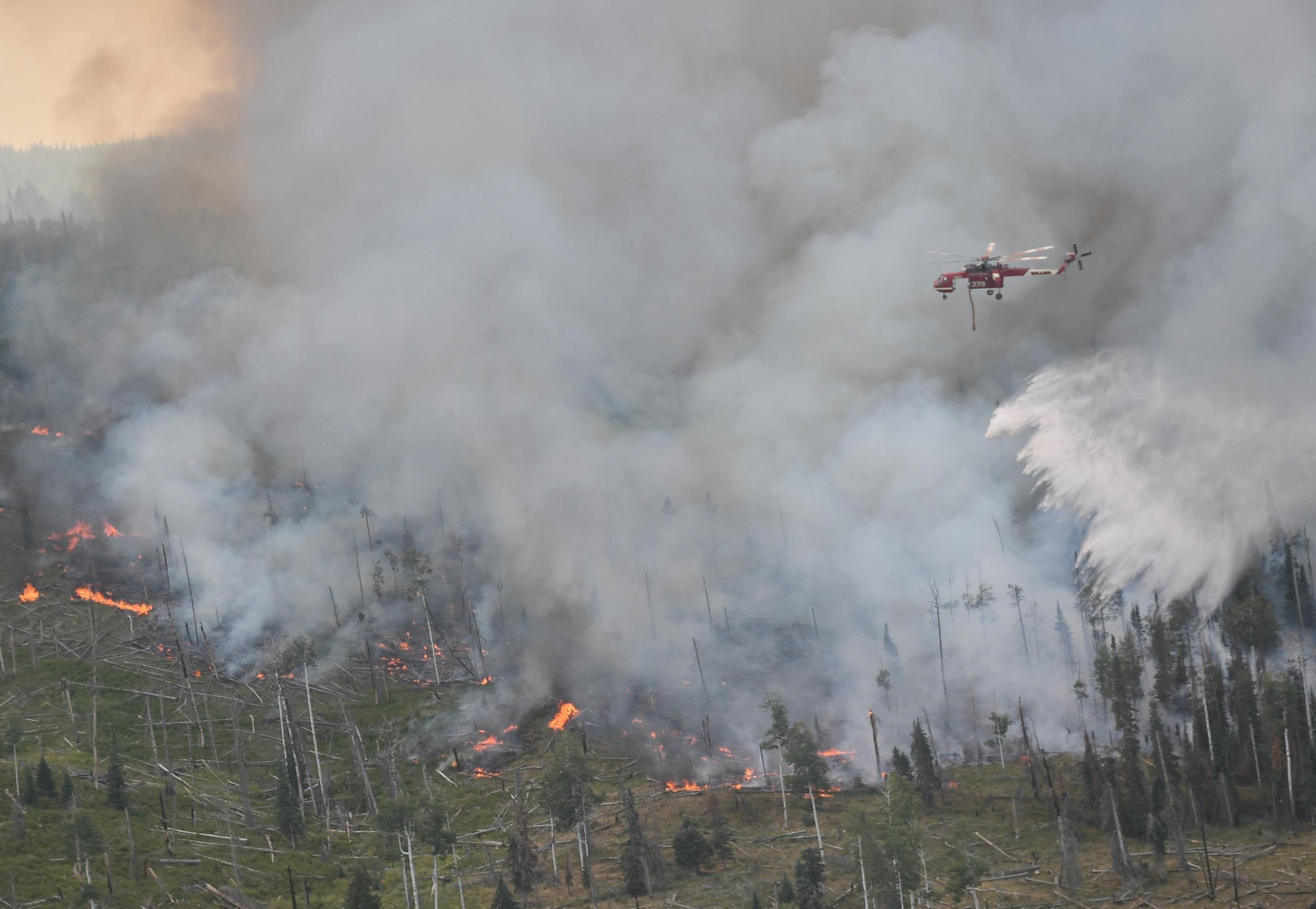
Air support is a major component of fighting wildfires. Silver Creek Fire has three helicopters that support the work of firefighters on the ground. #Silvercreekfire
The fire burned 4,780 acres and was 13 percent contained. A community meeting was scheduled for Tuesday at 6 p.m. at the CSU Extension Office, 210 11th St., Kremmling, Colorado.
Cabin Lake Fire Threatens Structures
Forty-six residences and 81 other structures are still threatened in the fire, according to Rio Blanco County Sheriff’s Office. Cabin Lake Fire has burned 6,072 acres and is 53 percent contained. Firefighters have improved fire lines around the perimeter of the fire.


Aug. 20 Updates:
Bull Draw Fire Near Nucla
The Bull Draw Fire grew to 28,390 acres Monday morning and was 21 percent contained, according to the fire’s Facebook page, managed by Bull Draw Fire staff in Nucla. Drier conditions are expected through Monday and moisture is anticipated on Tuesday.


National Forest lands on the Uncompahgre Plateau and Grand Mesa, BLM lands within the Uncompahgre Plateau Resource Area and unincorporated lands in Montrose and Mesa counties are under stage 1 fire restrictions. Fireworks and open campfires are not allowed among other restrictions.
The fire grew about 3,000 acres last week, but has since slowed. It is the 16th largest wildfire in state history, according to The Denver Post.
Other closures and restrictions:
A 17-mile section of the Divide Road remains closed. The closure is from the junction of Brushy Ridge National Forest Service Road #408.
Divide Road NFSR #402, to the Windy Point junction National Forest Service Road #600.
Divide Road National Forest Service Road #402. For questions concerning this closure please call the Grand Valley Ranger District at 970-242-8211.
The fire was burning 12 miles northwest of Nucla on the Western Slope close to the Utah border. It started on July 29 from a lightning strike.
Silver Creek Fire Near Kremmling
Higher humidity and lower temperatures brought minimal activity to the Silver Creek Fire over the weekend, according to Grand County Office of Emergency Management’s Facebook page.
The Silver Creek Fire burned 4,778 acres and was 5 percent contained Monday morning. Zero structures have been lost. Grand and Routt counties are under stage 1 fire restrictions along with Routt National Forest System Lands.

Colorado Highway 134, Latigo Ranch, Old Park and Gore Lakes are still under mandatory evacuation.
Other closures and restrictions:
Forest Service Road 100 (Buffalo Park Road) is closed from the Forest Boundary in the south to the intersection of the Road and Highway 40 to the north.
Forest Service Road 312, the Muddy Creek Trailhead north and across Highway 40, is closed.
Forest Service Road 250 is closed to the north from its intersection with Colorado Highway 134.
Cabin Lake Fire Near Meeker
The fire burned 6,072 acres and was 40 percent contained Monday morning, according to the Rio Blanco Sheriff’s Office’s Facebook page.
No structures have been lost or damaged but 46 residences and 81 other structures were at threat, the Sheriff’s Office said. Rain prevented the fire from spreading much further over the weekend, but larger-sized fuels continued causing heavy smoke.

All forest and BLM lands west of Main Marvine trail and drainage remain closed. The closure includes the entire South Fork drainage and all associated trailheads and campgrounds. All forest land east of the West Fork of North Elk Creek and south of Buford and Lake Avery to the Blanco District Boundary are also closed. Rio Blanco County Road 12 and the Main Marvine Trail were not affected.
Extreme fire behavior early last week prompted additional mandatory evacuations for residents on County Road 10. County Road 17 remains under a pre-evacuation.
Other restrictions and closures:
The Buford New Castle Road remains closed at the intersection of County Road 10 and County Road 17 and south to the turnoff to the Meadow Lake Campground (Forest Service Road 601).
County Road 10 is open to residents only between the intersection of County Road 10 and County Road 17.
A temporary flight restriction remains in effect.
For more evacuation information call the Rio Blanco Sheriff’s Dispatch Center at 970-878-9600 or sign up for their alerts.
The cause of the fire is under investigation.
Lake Christine Fire Near Basalt
After over a month of firefighting operations, the Lake Christine Fire continues, burning 12,588 acres, according to Inciweb. The fire is 90 percent contained and is burning 1 mile away from Basalt near Fort Garland.
The Lake Christine Fire was more active last week because of warm temperatures and low humidity, torching unburned fuel within the fire perimeter.
Warm and dry conditions make fighting the fire difficult, officials there say. But the potential for the fire spreading is minimal at the moment.
The Lake Christine Fire began July 3 and spread rapidly on July 4, destroying three homes. Authorities said the fire started by using tracer rounds at a firing range. Two suspects in their 20s turned themselves in July 15.
Cache Creek Fire Near Battlement Mesa
The Cache Creek Fire was 40 percent contained and has burned 2,708 acres by Monday morning, according to Inciweb. A fire spot was visible near Battlement Mesa, Parachute and Rifle on Friday evening. Crews took advantage of the rain and moisture over the weekend, but thunderstorm winds, dry fuel conditions and access to an aerial view of the fire continue to be a challenge.
The fire was 60 percent contained before the fire spot. Cache Creek Fire was caused by lightning.
Moccasin Mesa Fire Near Mesa Verde
The Moccasin Mesa Fire has burned 185 acres near the Southeast boundary of Mesa Verde National Park. The fire is 100 percent contained, according to InciWeb. It was reported by Park Point Lookout on Aug. 4 and was caused by lightning.
Plateau Fire near Dolores
The Plateau Fire in the San Juan National Forest northeast of Dolores and the McPhee Reservoir has burned 19,554 acres and was 95 percent contained on Saturday morning, according to the San Juan National Forest’s Facebook page. The fire has been burning since July 22 and was caused by lightning.
Green Mountain Fire Near Gunnison
The Green Mountain Fire, burning 25 miles southeast of Gunnison, was 100 percent contained. Fifty-three acres burned, according to a news release from the U.S. Forest Service. The cause of the fire is unknown and no damages were reported.
Sugarloaf Fire Near Fraser
The Sugarloaf Fire burned 1,280 acres and was 35 percent contained by Aug. 10. The fire is 13 miles southwest of Fraser and was started by lightning.
Buttermilk Fire In Gunnison Gorge
The Buttermilk Fire, burning in the Gunnison Gorge National Conservation area, burned 748 acres and was 70 percent contained Aug. 14. The C77 Road was closed to the public. Smoke may be visible in Delta and Montrose counties.
West Guard Fire Near Dove Creek
The West Guard Fire, burning 13 miles east of Dove Creek, northwest of Dolores, was caused by lightning. It was 100 percent contained and had burned 1,424 acres. The fire was started by lightning and was discovered by a helicopter working on the Plateau Fire.