Editor's Note: This post collects all of the updates for Colorado's wildfire season for Tuesday, Aug. 18. 2020. You can find the latest news on the fires here. Our original post continues below.
Colorado's four major wildfires have burned just over 130,000 acres in total. That's more than triple the acres burned the state in 2019, yet only a quarter of what was blackened in 2018. Proof of just how cyclical our fire season has become.
Gov. Jared Polis has just announced a 30-day moratorium on open fires and fireworks in the state, noting that all but the Pine Gulch fire were likely started by humans.
Here are the current statuses of Colorado’s four wildfires (click on the fire name to jump to the updates):
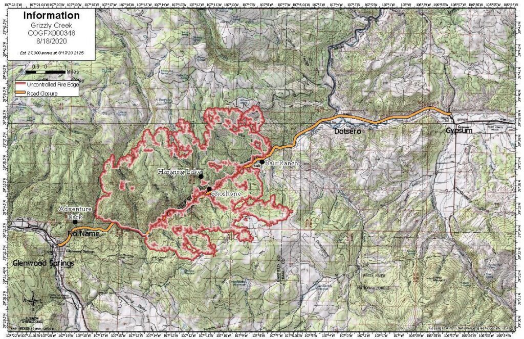
- Grizzly Creek Fire: 27,000 acres, no containment (Aug 18, 3:30 p.m.)
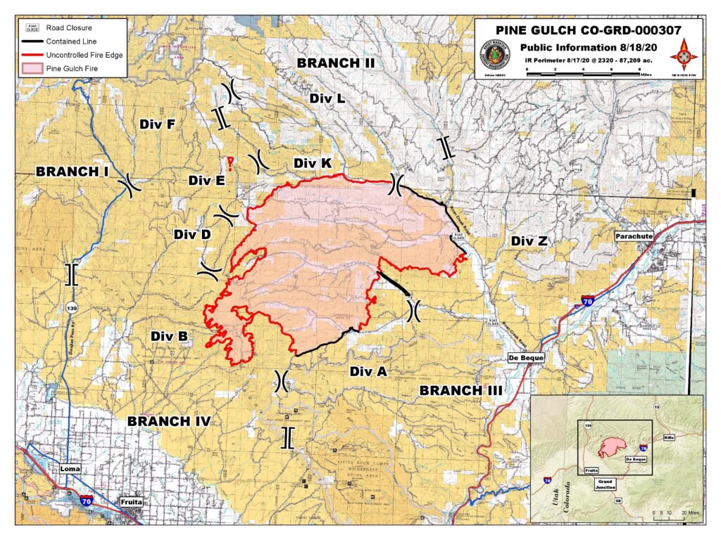
- Pine Gulch Fire: 87,778 acres, 7 percent containment (Aug 18, 7:54 p.m.)
- Cameron Peak Fire: 14,018 acres, no containment (Aug 18, 6:28 p.m.)
- Williams Fork Fire: 6,627 acres, no containment (Aug 18, 9:32 a.m.)
Grizzly Creek
7:16 p.m.: The Grizzly Creek fire may have damaged crucial watershed infrastructure in Glenwood Springs and on Interstate 70.
Lisa Stoeffler with the White River National Forest says normally, they would assess damage after a fire is contained. That was not the case this time.
"In this case, we've brought in a team immediately, right now, still in the early stages of the fire, to evaluate the impacts to I-70 and Glenwood Springs water system in Grizzly and No Name Creek," Stoeffler said.
— Paolo Zialcita
2:25 p.m.: Department of Public Safety Director Stan Hilkey said investigators now believe the fire was caused by something that dragged beneath or behind a vehicle along Interstate 70, creating sparks that lit the dry vegetation to the side of the highway.
1:35 p.m.: A Facebook Live community meeting for the Grizzly Creek fire is planned for this evening starting at 6 p.m.
11:54 a.m.: Officials say Grizzly Creek remains zero percent contained. More than 700 people are working to control the blaze. Crews are working focused on protecting structures in the No Name community and subdivisions around the fire. I-70 remains closed between Glenwood Springs and Gypsum with no estimated reopening time. A live meeting to update residents on the fire will be held at 6 tonight on Facebook.
7:39 a.m.: It's still hot and dry in the area but the wind has died down a bit in the last 24 hours, and the fire has moved to higher terrain. The favorable weather conditions allowed air support to continue with water and retardant drops.
Information officer Brian Scott said the fire has been less active.
"It’s just running out of the large conifer fuels and getting up on top where there's more smaller brush and grasses," he said. "And so those fuels will carry the fire slower and allow us our firefighters to make better progress."
Scott said the containment is still zero. The good news is that more crews and resources arrived on site Monday and should help make thicker, stronger fire lines. Officials said that structure protection was ongoing in Bair Ranch and No Name with "no loss of structures."
Pine Gulch
7:10 p.m.: Pre-evacuation orders have been issued for areas around County Road 205, Kimball Mountain Road and CR 256 in between Kimball Mountain road and Browns Point.
The orders come after a spot fire quickly grew to more than 100 acres in the northwest corner of the wildfire, threatening residents nearby.
The Pine Gulch fire is now the third-largest fire in Colorado history.
4:37 p.m.: There are dozens of oil and gas wells in and around the perimeter of the Pine Gulch fire, and some in the southwest portion have already been confirmed as damaged.
Crews are working with companies to protect infrastructure from further fire damage, fire official Pat Seekins said.
“(We're) identifying those gas lines, those oil well sites that are of concern, whether they're threat or damaged, so they can get assessments of where the fire is going," Seekins said. "We want to get ahead of that, which we feel like we are.”
Most oil and gas infrastructure has been unaffected by the fire, and threat assessments are ongoing.
— Paolo Zialcita
8:40 a.m.: Garfield County Sheriff Lou Vallario said some mandatory evacuations for residents will be lifted Tuesday afternoon. Officials are working with the power company to provide power to people who live along several county roads near the fire so they can return to their homes. But Vallario noted fire behavior is still unpredictable and people should be prepared to evacuate again.
7:39 a.m.: The Pine Gulch fire north of Grand Junction has been 7 percent contained over the past several days, even while the fire has ballooned in size. Fire information officer John Peterson said containing a fire means building a control line that flames won’t spread past.
"We'll add more line on a daily basis saying this is contained, but the fire is growing," he said. "So proportionally, it's still staying at about 7 percent."
The Pine Gulch fire became Colorado’s fourth-largest fire ever late last week and is just short — by 75 acres — of the 87,284 acres lost to the 2012 High Park fire.
Cameron Peak
4:06 p.m.: Rocky Mountain National Park has closed a portion of the northwest side of the popular destination "in an abundance of caution" due to forecasted conditions with the Cameron Peak fire. The park says flames are approximately 4 miles from the boundary.
2:25 p.m.: Public Safety Director Stan Hilkey said investigators believe the fire was human caused, because there was no indication of lightning in the area when the fire began.
1:31 p.m.: There will be a community meeting about the Cameron Peak fire on Facebook Live at 5:30 p.m. An update about current conditions will be given and fire officials will take chat questions.
12:29 p.m.: Larimer County has adopted an open fire ban effective Aug. 18 until Sept. 18, 2020.
The fire ban includes open fires, welding, fireworks, smoking in the open on trails, parks, open spaces or outside of buildings. The ban replaces an earlier restriction issued in July. Read the full ordinance.
11:12 a.m: The fire's most significant growth on Monday came along the west and southwest edges. Crews in that are contained several hotspots across Highway 14 and Lond Draw Road said fire officials. Managers also said they've engaged Colorado State University and Rocky Mountain National Park to consult on the placement of potential containment lines along the south edge of the fire.
10:00 a.m.: From the Larimer County Sheriff on Twitter: "The Pingree Park area is closed to all recreational activities/hiking. No new evacs or road closures at this time."
8:59 a.m.: Rocky Mountain National Park closed the Alpine Visitor Center atop Trail Ridge Road on Monday due to smokey conditions. From the visitor center, the Cameron Peak fire is just over 13 miles to the northwest.
7:39 a.m.: This fire is in the Arapaho and Roosevelt National Forests near Cameron Pass and Chambers Lake. Winds are pushing the flames to the west and southwest. Helicopters are working to keep the fire from crossing either Long Draw Road or Colorado Highway 14 again.
Williams Fork
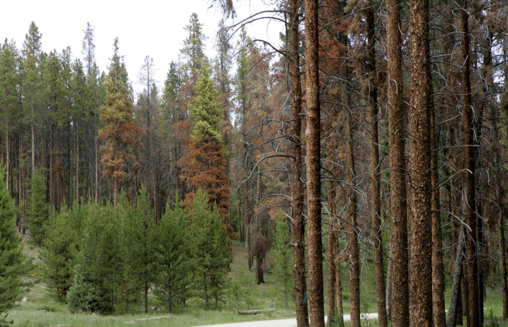
4:52 p.m.: Trees killed by the mountain pine beetle have fueled the Williams Fork fire and pose a danger to firefighters, said information officer Schelly Olson.
"This is a fuel type that's very dangerous to work in. We have dead trees that can fall on folks, on firefighters, called smags. So that is a hazard, and that really dictates how we fight this fire," Olson said.
— Paolo Ziaclita
2:25 p.m.: Like the Cameron Peak fire, Public Safety Director Stan Hilkey said investigators believe the Williams Fork fire was human caused, because there was no lightning detected in the area where the fire began.
1:41 p.m.: An informational meeting about the Williams Fork fire is planned for tonight at 5 p.m. along with a question and answer session on Facebook Live.
9:13 a.m.: No substantial change in fire size has been reported for the William Fork fire thanks to northeast winds. The fire interior is active and a smoke column could be seen most of Monday.
As a result of an analysis conducted over the weekend, officials say a Type 1 Incident Management team will soon assume responsibility and command. These types of teams are highly trained and usually take on fires that are complex and require a high degree of coordination between local, regional, state and national resources.
7:39 a.m.: Fire official Brad Johnson said the southeast section of the fire is threatening several key pieces of infrastructure like "the Henderson Mine, the power utility poles [and] the infrastructure with the natural gas company."
Monday was an active day for the blaze, as it moved east toward Lake Evelyn. Crews had some success in slowing progress with retardant drops from air support.
Officials say the Williams Fork fire is human-caused after they ruled out lightning. The exact cause of the fire is unknown.