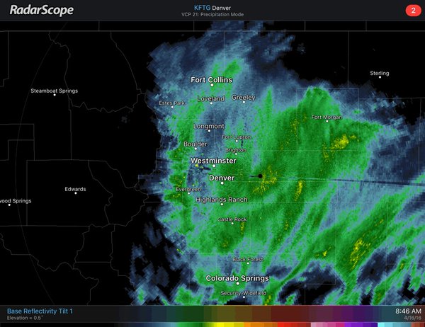
Bands/snow will rotate into northeast CO from the east. Sf rates up to 2"/hr will be psbl with heavier bands. #cowx pic.twitter.com/mzDt4cLfn2
Airlines at Denver International Airport canceled more than 800 flights Saturday as a spring storm expected to dump up to several feet of snow began to move along the eastern foothills of Colorado and Wyoming.
Our teams continue to tackle the snow - Photos via our multi-talented @Garry442 pic.twitter.com/DbPfjOeEpW
- Forecast: NWS Maps | Twitter
- Airport: Flight Status | Twitter
- Roads: CoTrip | Twitter
- Transit: RTD Alerts | Twitter
- Xcel: Updates | Outage Map
Up to 2 feet of snow was reported between Denver and the Continental Divide on Saturday. Heavy rain on the Eastern Plains prompted flood warnings in eastern Colorado, but no severe damage has been reported.
CDOT put traction laws into effect on some mountain highways and passes Saturday, and reported some accidents both in the mountains and Front Range, but began lifting the rules in some locations in the afternoon. As conditions on the Plains deteriorated, some roads are being closed or opened as conditions warrant.
What a difference a day makes. Travel is risky. Please stay off the roads. #Aprilstorm2016 pic.twitter.com/eKXlkcUhiW
In Denver, the annual 4/20 festival celebrating all things marijuana has been postponed. Wiz Khalifa and Lil Wayne had been scheduled to perform. There's no word on a makeup date.
Xcel Energy said Saturday morning that power to about 8,000 customers was lost because of the storm, mostly around the Front Range, Pitkin County, Salida, and the San Luis Valley. By afternoon, crews had cut that number to 3,500. Check the Xcel outage map here for updates.
Ahead of the storm, NWS Meteorologist Kari Bowen told CPR's Jo Ann Allen that we shouldn't focus on the amount of snow that could fall -- which in some places could be measured in feet. This storm's really more about length.
"We know people are very interested in amounts only because it does make sense in their head that, you know, 14 inches is a lot," she said Friday. "But since it's a prolonged event, it's going to cause some impact to people's weekend plans, so we just want people to come to think about that."
Here is the latest radar loop. Snowfall rates up to 3" per hour will be possible with heavier bands. #cowx pic.twitter.com/gvapp7CXAG
Jim Kalina of the National Weather Service in Boulder and Brian Chapman of the National Weather Service in Cheyenne say rain is changing to snow and temperatures are falling, which could bring more heavy, wet snow over the next two days.
CPR's Bob Lafley writes that highs today will be in the low to mid 30s for Denver and Boulder but winds will increase with gusts to 30 mph or stronger. Heavy wet snow is still expected into this evening, with light snow overnight and again on Sunday.
In western Colorado, there are rain showers for Grand Junction. Highs in the 40s with winds up to 25 mph with stronger gusts today and tonight. There's a slight chance for rain showers Sunday out west with highs in the 50s.
The central mountains and valleys have a winter storm warning until Sunday evening. Mountain highs in the 30s with gusty winds. Lows tonight will be in the teens and 20s.