Layers of snowpack melted rapidly in Colorado in April, which could lead to less water supply in the summer and higher wildfire potential, according to data from the National Integrated Drought Information System.
The federal data, released on May 1, indicate that “substantial and rapid” snowmelt occurred throughout broad swaths of Colorado between April 10-17. Several weather stations maintained by the U.S. Department of Agriculture logged record snowmelt during that week, compared to the same period in prior years. Snow disappeared up to 4 weeks early in parts of Colorado compared to previous years, federal data show.
How quickly snow melts, and when it happens, can impact water availability during hot summer months and affect how likely wildfires are to occur in a region. An area that’s seen rapid snowmelt in early spring could have dried-out vegetation by summer, a potential fuel for blazes.
“Snow drought” indicates unusually low levels of snowpack, which can be driven by low snowfall during the winter, precipitation falling as rain instead of snow, or a lack of snow accumulation because of warm temperatures. Much of the Southwest remains in snow drought conditions, according to the federal data.
Spring heat waves in early April rapidly melted snow across Colorado’s Rocky Mountains, leading to large drops in the state’s median “snow water equivalent,” compared to past levels. Snow water equivalent (SWE) measures how much liquid water is stored in the snow, which will eventually melt and flow into the soil and bodies of water.
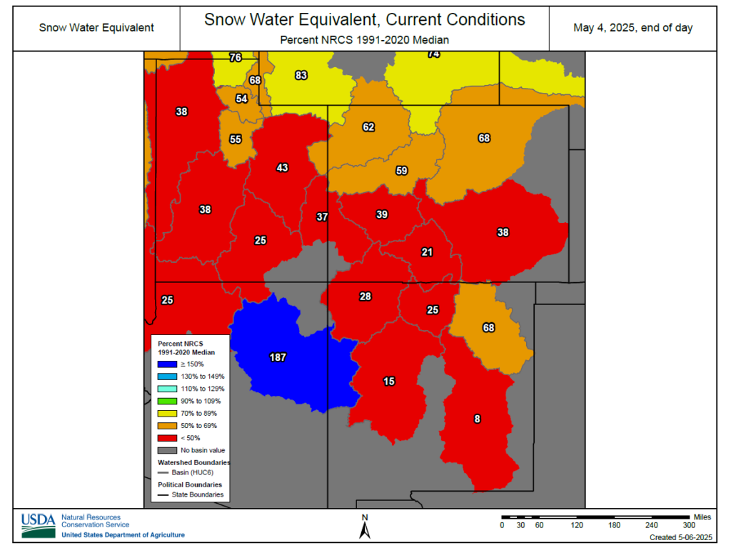
Many of Colorado’s watersheds are now at very low levels of SWE, which could be a problem as the state begins to face higher temperatures. Dry and warm conditions drove the rapid snowmelt after the first week of April. For instance, SWE in the Colorado River headwaters basin, in Rocky Mountain National Park, was near normal median levels in early April, but has dropped sharply in the last month.
Snow conditions are “dire” in places like the Upper San Juan basin and the Gunnison basin, according to federal data.
While some precipitation may occur during the next week in Colorado’s Rockies, major increases in the state’s snowpack are unlikely. A winter storm warning for the foothills near the Denver metro area Tuesday could bring up to 20 inches of snow to higher elevations, but much lighter snow is expected in Summit County to Vail Pass with just rain in the metro area.
The federal data also show that water supply forecasts for the Upper Colorado River Basin – an area that stretches four states including Colorado – declined compared to rosier projections from early April.