according to the National Weather Service. The NWS Denver office is predicting snow to pick up Saturday afternoon, with roads in the metro-area becoming potentially treacherous later in the day.
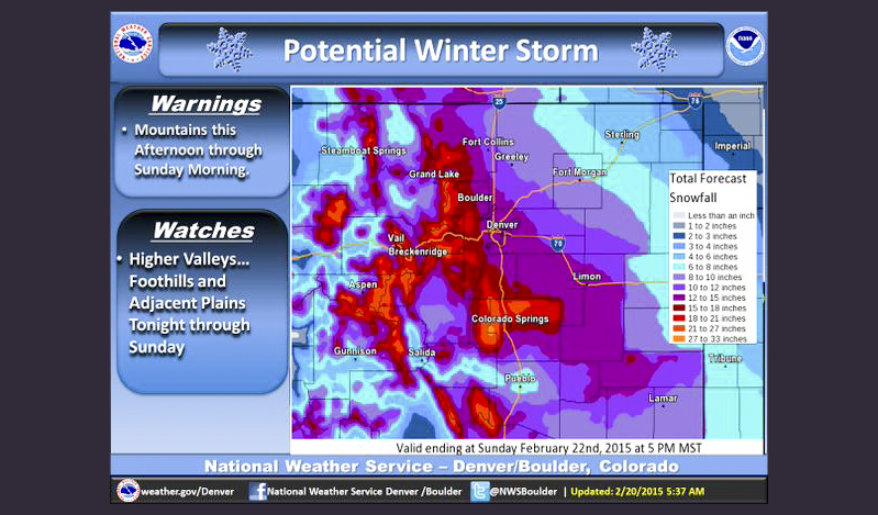
Much of eastern Colorado is under a winter storm warning until Sunday evening. The plains could see 6-10 inches of snow, the foothills are forecast to get significantly more, up to a foot and a half.
A CDOT official described driving conditions around the state as"not too bad right now" in an interview with CBS-channel 4. The Department reports that I-70 is snowpacked, but open through the mountains. Wrecks kept the highway closed for several hours between Georgetown and Silverthorne Friday afternoon. Westbound traffic is heavy, but moving along the interstate from Floyd Hill through Summit County. Loveland Pass is currently closed. |
Denver International Airport says 77 flights have been canceled so far due to the storm, generally all smaller flights to mountain destinations. By 6:45am, the airport measured around 1" of snowfall so far. Planes are going through de-icing before takeoff, but all runways are currently open. DIA is urging passengers to check flight status before heading to the airport, especially as the storm picks up later in the day.
Colorado is on the tail end of what some forecasters are calling the 'Siberian Express,' a major winter storm bringing snow, ice, and frigid temperatures to the eastern half of the country.
***
A winter snowstorm packing a one-two punch is moving into Colorado, bringing two feet of snow or more to some areas of the state.
Outside of the mountains, snow isn't expected until mid- to late Friday evening, according to the National Weather Service. The Front Range and Denver could see rain beginning during rush hour this evening, but it will quickly turn to snow, explained NWS Meteorologist Kyle Fredin.
Once it starts falling, most snow is expected on Saturday night, though accumulation isn't expected to stop until Sunday.
“The way it looks right now much of the urban corridor could land in that 8-16 inch range," said Fredin. "Lesser amounts out on the plains and on up to the Wyoming boarder but the foothills always do best with situations like this and they’ll probably be in the teens or even higher."
Much of the state will be under a winter storm watch from Friday night until Sunday night.
Winter Storm Watch Fri. Night-Sun. Night. Worst conditions for Front Range & Ern Plains will be Sat.PM-Sun. #cowx pic.twitter.com/HHztRCyswM
Denver is preparing their fleet of "big plows" to be available on midnight Friday, and will have residential snow plows starting at noon Saturday if necessary, according to Denver Public Works.
"While Denver’s 70 big plows will focus on clearing snow and distributing de-icing materials on Denver’s main streets, 96 smaller, residential plows are ready hit the side streets, if warranted," said the agency.
At Denver International Airport, airlines will be deicing their aircraft through the duration of the weekend, said spokesperson Heath Montgomery.
"And that of course means passengers will spend a little extra time in the aircraft before departure. It’s also critical that passengers continue check their flight status," he added.
The storm is forecast to move out of the area Monday evening.
CPR's Nathan Heffel contributed to this report.