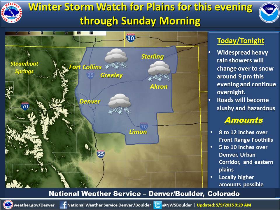
Winter Storm Watch added this evening through Sunday morning for Foothills, Denver/Urban Corridor and Plains. #cowx pic.twitter.com/P6pb7REUXy
Be prepared and on alert for flooding in your area. NEVER drive over a flooded road! #cowx #floodsafety pic.twitter.com/L0SIU6kvdx
Yes, it's still raining. But wait, there's more. Picking up from where we left off yesterday...
A long stretch of stormy weather continues over Colorado, with more rain for the Front Range, and snow this weekend in the mountains. Meantime, the steady rain all this week has raised the threat of flooding around metro Denver, and in Boulder and Larimer counties.
The Associated Press reports that rising river levels fed by heavy rains have forced the evacuation of the St. Vrain Campground in northern Colorado. Weld County spokeswoman Jennifer Finch says the Frederick-Firestone Fire Protection District issued the mandatory evacuation of all park guests around 11:30 p.m. Friday.
The National Weather Service reported a few landslides along the Saint Vrain in Boulder County and minor flooding in several businesses In Lyons. The Carbon Valley Emergency Operations Center has been activated to assist with evacuations and monitoring road closures.
Nezette Rydell of the National Weather Service in Boulder tells CPR's Bob Lafley that a winter storm warning is in effect from noon Saturday to 9 p.m. Sunday for the central mountains and valleys. Expect the heaviest snowfall Saturday night, with accumulations of 4-8 inches , and perhaps even 12 inches for some places over 10,000 feet.
The weather service has also issued a tornado watch for Baca, Bent, Cheyenne, Crowley, Elbert, Kiowa, Kit Carson, Lincoln, Logan, Morgan, Otero, Phillips, Prowers, Sedgwick, Washington and Yuma counties.
Tornado watch for far eastern plains until 9 pm. #cowx pic.twitter.com/XNJCrFSdKR
The rain drenched CU Boulder's commencement exercises:
Localized flooding in #Boulder County as rain continues at "gentle" pace http://t.co/5teHUNaI0t via @SarahKuta pic.twitter.com/3CcFnU9qVm
The Poudre River's dunning high:
Poudre River is grumpy right now @ College in Fort Collins. 2,300cfs and building. AVOID banks -- could be unstable. pic.twitter.com/N7ThT8HAIO
The National Weather Service is offering tornado safety tips:
#cowx Severe Thunderstorms and possibly a Tornado or 2 through the Eastern Plains. Do you know what to do? pic.twitter.com/6Urp8XYkRO
Rain is mucking things up in Colorado Springs:
There was a lot more movement in the Westside retaining wall after heavy storm Saturday morning @csgazette pic.twitter.com/sBnrUO7MZo
There's snow in Durango:
Sheriffs turning west bound traffic around at Durango West for traffic accident near Mancos Hill pic.twitter.com/l8oiKAhZx2