Ever since the Colorado Department of Transportation closed Interstate 70 at Glenwood Canyon because of the nearby Grizzly Creek Fire, motorists have tried to find alternative routes in and out of the Roaring Fork Valley.
First, they used well-known passes like Independence and Cottonwood. Then local authorities and the state closed them when too-long commercial trucks or trucks hauling trailers got stuck.
Then, lesser-known roads like Crooked Creek Pass and the Eagle-Thomasville Road filled up with thousands of vehicles, said Amber Barrett, a public information officer for the Eagle County Sheriff's Office.
"We cannot stress enough that these 4x4 mountain roads, dirt trails, are not passable for your standard travelers — for sedans with low clearance, trucks, trailers, anything like that," Barrett said. "It's just absolutely not safe for those types of vehicles to be on those mountain roads."
Those two routes have since been closed too, Barrett said. But before that happened, Will Treuth said that he drove Crooked Creek Pass on Wednesday — a two-and-a-half-hour journey.
"We drove down some 60 degree angled drops with very little traction, over sharp rocks," he posted.
Google Maps advised him to take the road, he wrote. He didn't immediately respond to an interview request.
Michael Hunter of Columbus, Ohio, said he wasn't even aware of the fire as he and his wife vacationed up-valley in Snowmass. Then on Wednesday, they started to head back toward Denver in their rented Dodge Durango when Google Maps sent them over one of the rough passes — Crooked Creek most likely, he said.
"I was having a hard time find the exact route," he said.
"There were times we had people coming through with campers and extended vehicles. You're just kind of waiting on the edge for them to go by," he added. "I think myself and a lot of other people definitely didn't know what we were getting into."
Colorado Department of Transportation spokesman Matt Inzeo said the agency has been working with Google to remove the inappropriate routes. A Google spokesperson said the company will no longer route users down narrow, unpaved roads — a change that they said will take 24 hours to go into effect.
"When we’re made aware of routing issues, we work quickly to fix them," the spokesperson wrote in an email.
An Apple Maps search Thursday afternoon also advised taking a back road. CDOT's Inzeo said motorists will need to take some responsibility themselves.
"With an active fire season, travelers will need to plan ahead and know what route they can take," he wrote in an email.
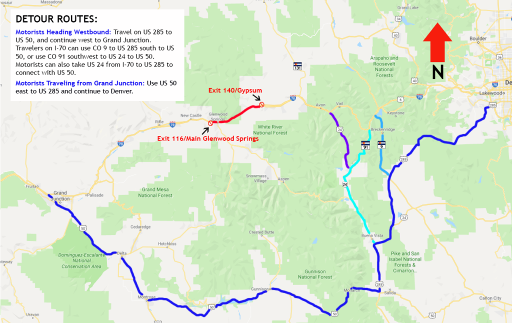
CDOT recommends drivers going between Denver and Grand Junction use a combination of U.S. 285 and U.S. 50 as an alternative to I-70.
The Eagle County Sheriff has posted deputies at the base of a handful of mountain roads to turn motorists away, Barrett said. But they're stretched thin and might have to leave their post to help others who've gotten themselves stuck.
"Everyone is just trying to sneak through," she said, adding that, "the roads have just been trashed."