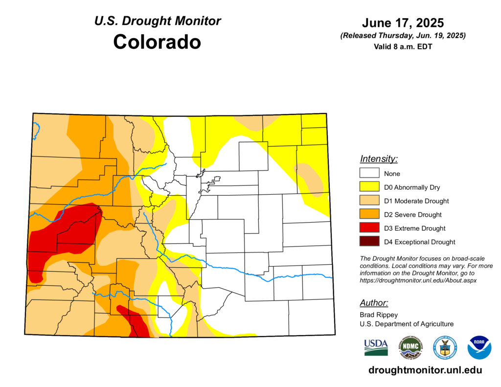
The western half of the state is experiencing a moderate to severe drought, with some municipalities imposing water usage restrictions. Meanwhile, most of the Arkansas River Basin and parts of the Front Range and eastern Colorado are currently fine, according to the latest U.S. Drought Monitor report.
That report does not reflect effects from the recent heat wave. Also, Chaffee County and Lake County, which are part of the Arkansas watershed, are in a moderate drought.
Justin Louen is a hydrologist with the National Weather Service in Pueblo. Despite having a below-average snow year overall, Louen said the Arkansas River Basin had the strongest snowpack in the state compared with other major basins.
“(The Arkansas River Basin) is probably the best performing area of the state for snowpack,” Louen said. “The remaining mountain snowpack in other mountain ranges throughout the state were all trending either below or well below normal.”
Frequent afternoon rain showers and rainy days have also helped keep things wet in the region.
“That effectively has helped boost soil moisture levels and reduce what would otherwise be pretty stressful on vegetation and crops and everything else,” Louen said.
The Arkansas River is still below average when it comes to stream flow this summer. Its basin had a strong snowpack in the mountains near the Continental Divide, but less in the Sangre De Cristo mountain range, Louen said. Warmer temperatures earlier in the year also ate into the summer's available water.
“Starting in mid-April or so, we did see that snowpack melt out a lot quicker than normal,” Louen said. “That could also be contributing to the fact that we are seeing peak flows on the river here in mid-June, being just a little below normal as well.”
Looking ahead, the Climate Prediction Center forecasts some likely hotter-than-average temperatures for the state throughout this summer. As for water, the 30-day forecast shows precipitation possibly lower than usual, but the three-month forecast is predicting around average precipitation.
Louen said it's a toss-up between drier weather predictions and possible July monsoons.
“It's just been a little bit of a roller coaster in general,” Louen said.