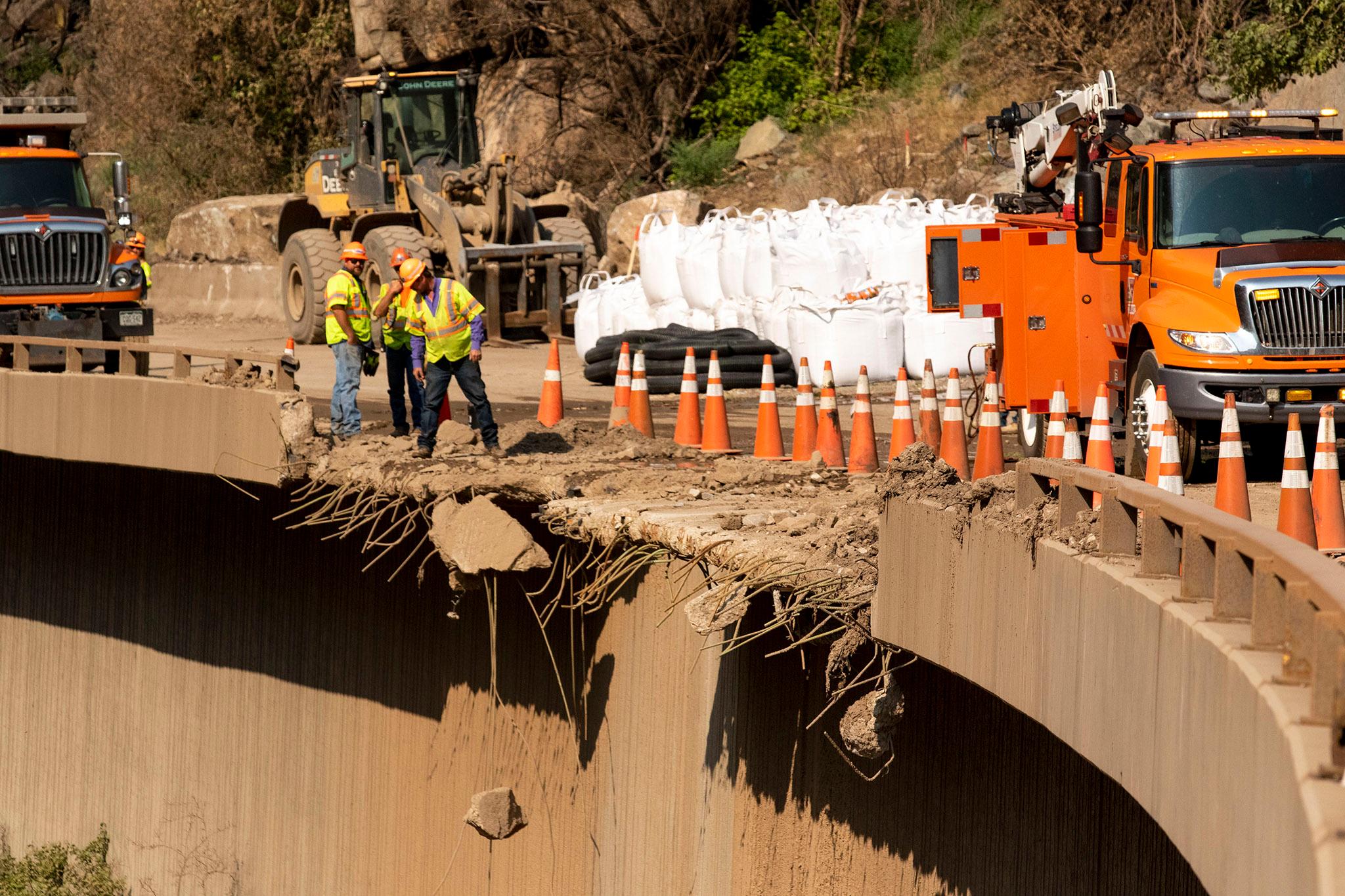
Last summer, mudslides wreaked havoc on a 12-mile stretch of Interstate 70 through Glenwood Canyon, forcing drivers to take hours-long detours and at one point trapping more than 100 people in a tunnel overnight.
In the months since, state and local transportation officials have been focused on cleaning up the massive piles of debris from nearby wildfire burn scars and developing plans to prevent future closures. They outlined more than $27 million dollars in mitigation efforts during an event held at a rest stop in the canyon on Tuesday.
“Hopefully this summer will be better than last summer,” said Steve Harelson, chief engineer with the Colorado Department of Transportation. “It’s going to just get better as mother nature heals the canyon.”
Chief among the improvements are a series of 3,000-pound “super sacks” that have been constructed at strategic points along the road. The makeshift walls, mostly made out of sandbags, are strong enough to catch slides similar to last summer’s, Harelson said.
“I like to call them bathtubs,” he said. “It’s a technique used in other parts of the world, but not so much in Colorado.”
CDOT teams have also placed absorbent mulch in large swaths of the Grizzly Creek Fire burn scar to help control runoff, and they’ve run two large-scale training exercises aimed at speeding up the agency’s response to mudslides that impact the highway.
Operations crews have also reworked their plans for implementing highway closures, Harelson said.
Over the last year, the agency has partnered with the National Weather Service to streamline how it determines whether to close the canyon to drivers. Crews will plan to briefly close the interstate through the canyon whenever a flood warning is issued in the Grizzly Creek burn scar area, said Todd Blake, CDOT’s deputy maintenance superintendent.
“At that point, we’ll sweep it to make sure no one is trapped in the canyon,” Blake said. “And then we’ll wait it out until the warning is over. Then we’ll come back and make sure we have no debris flows and make sure the canyon is opened back up.”
Officials also addressed plans to improve I-70 detours. A flood of traffic last summer caused headaches and safety concerns in communities located along alternative routes.
In the event of a closure, CDOT will plan to direct travelers to one recommended route, which will take people north of I-70 through Kremmling, Steamboat Springs and Craig, adding about two and a half hours to their journey.
Colorado State Patrol officers plan to step up efforts to direct drivers away from smaller mountain passes, which can be difficult for commercial trucks and some smaller cars to traverse, said Capt. Jared Rapp.
“Some of them aren’t dedicated to passenger vehicles and we’ve had to rescue many people during an already difficult time,” Rapp said. “My plea for people is to stay on the northern and southern routes.”
Efforts to improve Cottonwood Pass are still underway. Last fall, CDOT began a new mapping and right-of-way project to help lay the foundation for infrastructure improvements.
The pass will remain a county-controlled road, but it will likely see construction in upcoming years to help turn it into a better I-70 alternative, said Harelson.
“There are a number of grant opportunities in the bipartisan infrastructure law,” he said. “We’re trying to set ourselves up to turn this into something better than its current state as a Jeep-friendly road.”
Forest service crews are eyeing repairs to the trail leading to Hanging Lake, which suffered damage during last summer’s slides. Staff with the White River National Forest plan to start construction on a new “primitive” trail in the next few weeks.
The route should be open sometime this summer, said David Boyd, public affairs officer with the Forest Service.
“We’re already planning a more long-term sustainable trail, but that’s going to take a few years to get that done,” Boyd said.
Local governments have taken additional steps in response to last year’s mudslides. The city of Glenwood Springs has removed debris from above the town’s main water intake and constructed a second transfer pipeline along the Roaring Fork River, one of the town’s main sources of water.
“This redundancy work is important to safeguard our drinking water and our tourism economy,” said Johnathan Godes, the city’s mayor.
Officials urged tourists and travelers to do their part when traveling through the canyon this summer. CDOT has launched a new version of its COtrip app, which is designed to feed drivers more up-to-date information about detours.
The risk of mudslides this summer will ultimately depend on how much rain the region gets. Burn scars in the canyon will need another few years to completely heal, said Andrew Knapp, a CDOT engineer leading mitigation efforts.
“Unfortunately, in the canyon, mother nature has the final say,” Knapp said. “We can do the best to mitigate, but if we do have an extreme event, it will likely overcome those features.”