Editor's Note: This post collects all of CPR News' reporting on the four fires in Colorado for the weekend of Aug. 15-16. You can find the latest coverage here. Our original post continues below.
Fire officials are predicting another busy fire day, as hot and dry conditions continue — Friday, Aug. 14, started out with 3 major fires burning. Crews are now battling four major blazes across the state, including two on the Western Slope and two in the central mountains. The fires are sending smoke across the state. An air quality warning is in place through Saturday afternoon for the Front Range, with air reaching unhealthy levels for people who are sensitive.
Here are the current statuses of Colorado’s four wildfires (click on the fire name to jump to the updates):
- Grizzly Creek Fire: 25,690 acres, with no containment as of Aug. 16, 7:08 a.m.
- Pine Gulch Fire: 82,838 acres, with 7 percent containment as Aug. 16, 9:37 p.m.
- Cameron Peak Fire: 12,124 acres, with no containment as of Aug. 16, 5:45 p.m.
- Williams Fork Fire: 6,345 acres, with no containment as of Aug. 16, 5:23 p.m.
Grizzly Creek Fire
7:08 a.m. Updated acreage totals from the federally run Incident Information System site puts the fire at 25,690 acres burned. And between the high temperatures, already-dry ground and expected winds, another day of extreme fire activity is anticipated.
Saturday
6:15 p.m. Travel restrictions related to the Grizzly Creek Fire remain in place, including I-70's closure and the closure of Cottonwood Pass. Officials are urging people not to try dirt back roads to get around closures, as it can damage roads and create traffic snarls.
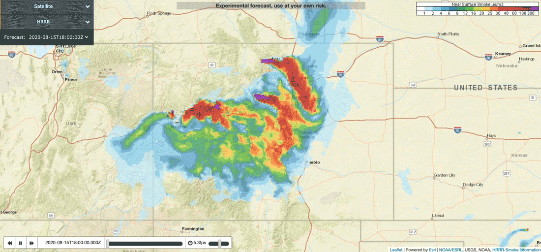
3:50 p.m. Smoke from the Grizzly Creek Fire, as well as the other fires, is affecting air quality nearby as well as throughout the state. Federal air quality monitors show moderate effects on air quality across the northern and central Front Range as well as in the central mountains.
Projections from NOAA, which are less reliable, show that winds could push the smoke south as the direction changes tomorrow.
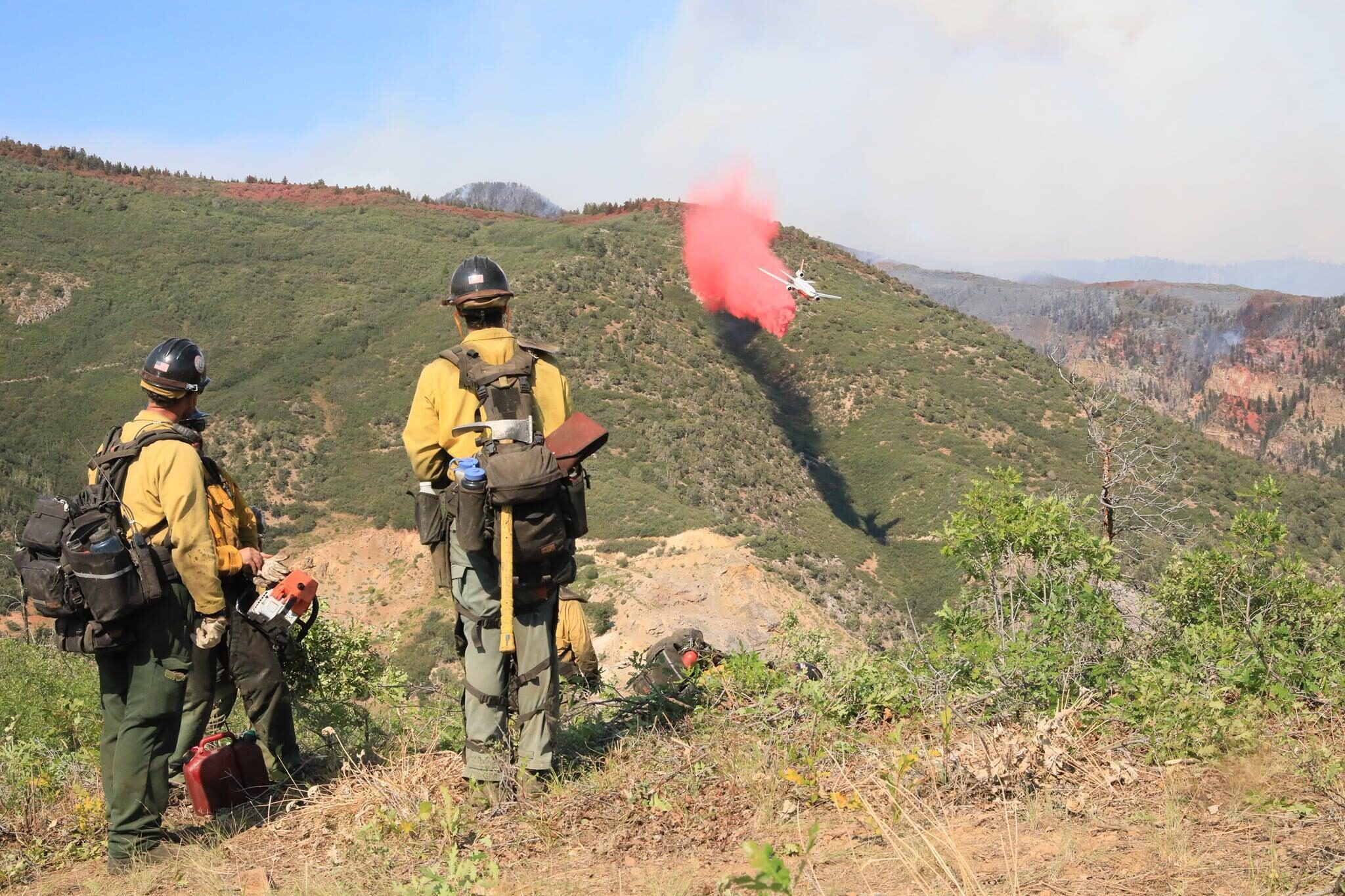
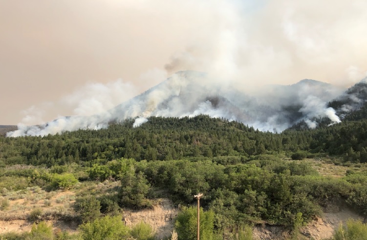
12:40 p.m.: Fire crews are preparing for the blaze to change direction tonight. The fire is currently burning between a mile and a mile and a half from Glenwood Springs. The shift in the wind tomorrow could bring it closer, said Wayne Patterson, a public information officer. It’s not a certainty, but the wind is expected to shift Sunday, which could push the fire farther south, towards the town. Incident command has crews working hard to accommodate that. They've got a couple of hot shot crews working fire lines. No new evacuations have been ordered yet.
There are currently 553 people fighting the fire. That should double in the next few days.
11:25 a.m.: Firefighters are trying to figure out if they can hook the fire north toward I-70. A hot shot crew will assess the northeast edge of the fire to see if they can place a direct line for future operations.
Fire activity near No Name, outside Glenwood Springs, has died down but firefighters still have helicopters in the area with fire retardant.
Winds are expected to push the fire south.
An inversion has helped keep smoke levels low but that could change as temperatures rise in the afternoon. — Taylor Allen
10:00 a.m.: Pre-evacuation orders remain in place for Dotsero and areas east of the fire. Vail Resorts has agreed to open up 65 rooms in employee housing, if people are evacuated, said Bruce Gillie, who oversees the evacuation center at Battle Mountain High School. The center at the high school will be focused on getting folks water, food, information and shelter, rather than providing beds. Gillie said that because the pre-evacuation order has been in effect for days, a lot of people left to stay elsewhere. At the moment, things remain relatively quiet. - Caitlyn Kim
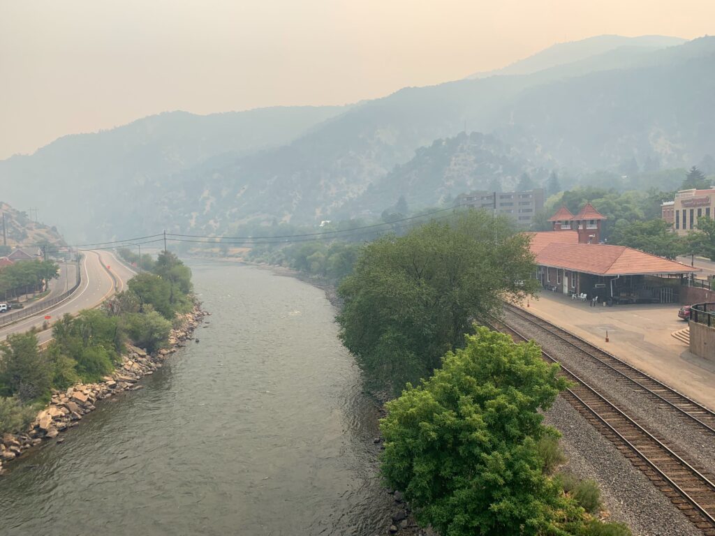
8:42 a.m.: The fire has closed I-70 indefinitely in Glenwood Canyon and 352 people are fighting the fire. Several hundred people have been evacuated, in No Name, Bair Ranch, Sweetwater, Coffee Pot Springs, High Aspen Ranch (CR 115), Coulter Creek, CR 120, Cottonwood Pass and Buck Point Drive. The Bureau of Land Management also closed recreation sites and boat ramps on the southern part of the Colorado River near Dotsero Friday night.
The fire burned around Hanging Lake, a popular hiking destination, but authorities confirmed Friday that the area immediately around the lake had not burned.
Pine Gulch Fire
11:11 a.m The Colorado Department of Public Health and Environment issued an air quality health advisory for points east of Pine Gulch and Grizzly Creek Fires. Widespread smoke will go downwind and particularly affect Craig and Meeker to the north along the I-70 corridor in central Colorado and as far east as the Front Range region and Eastern Plains. Smoke can be rated anywhere from "moderate" to levels that are "unhealthy to sensitive groups" levels to places northeast of the fire including Garfield, Moffat, Mesa, and Rio Blanco counties.
Pine Gulch Fire PIO Map 8-16-20 by CPR Digital on Scribd
10:05 a.m. The fire grew to 81,107 acres from yesterday and remains 7 percent contained. Red flag conditions continue on Sunday, with low humidity and high temperatures. Crews are expecting high rates of spread for the fire. All the orders for evacuations and road closures are still in place as of Sunday morning.
Saturday
6:00 p.m.: Fire activity ramped up Saturday afternoon, as the wind picked up. The fire moved towards Garfield Mesa, and firefighters have shifted their efforts there.
10:00 a.m. Overnight flights of the fire expanded estimates of the size of the fire, which remains just 7 percent contained. Smoke from the fire is expected to settle in the Grand Valley until early afternoon.
8:42 a.m. While it is mostly burning in uninhabited areas north of Grand Junction, residents of Roan Creek road, Clear Creek road, Carr Creek road, Brush Creek road and CR 202 have all been ordered to evacuate. A total of 757 people are dedicated to fighting the fire, according to Inciweb.
Cameron Peak Fire
2:51 p.m. The Colorado Department of Public Health and Environment issued an air quality health advisory because of smoke from the Cameron Peak fire and the Williams Fork fire. The affected areas include Jackson, Grand, Summit, Park, Clear Creek and Gilpin counties. The cities of Rand, Kremmling, Granby, Breckenridge, Silverthorne, Fairplay, Georgetown and Central City are also under the advisory.
11:18 a.m. The Cameron Peak Fire grew to 10,867 acres. No structures of campgrounds were damaged Saturday and overnight into Sunday. The fire crossed to the south side of Highway 14 in a second location between Barnes Meadow Reservoir and Long Draw Road. It grew to 10,867 acres. Less humidity is expected Sunday so that means less intense fire behavior. Although, winds from the east will push the fire west. Ground crews will focus primarily on protecting structures. Firefighters will use heavy equipment along Deadman and Pearl Beaver roads to clear roadside vegetation to create fuel breaks for future containment lines.
Saturday
10 a.m.: Firefighters are building lines to prevent the fire from spreading towards Red Feather Lakes or towards Colorado State University's Pingree Park campus. Operations Section Chief Trainee Beau Kidd said in a Facebook update that where the fire is burning in wilderness areas, they are letting it, but working to keep it away from structures.
8:42 a.m.: Located by Chamber Lake, west of Fort Collins, the fire grew rapidly on Friday, closing Hwy 14 through Poudre Canyon; 120 people are working to fight the fire. Evacuations are in place from Highway 14 north to Deadman Road and Four Corners, from Red Feather Lakes west to Cameron Pass. The area around Long Draw Reservoir is also under a mandatory evacuation order.
Williams Fork Fire
11:38 a.m. The Williams Fork Fire is estimated at 6,000 acres after a very active day On Saturday. The fire incident command is working with the Grand County sheriff on an evacuation plan for Fraser if needed. Officials say extreme fire behavior will continue Sunday and fire managers are expecting continued rapid growth in the afternoon. Hot and dry weather will persist. Forest closures are in effect west. of Winter Park and Fraser, and includes Vasquez Creek, St Louis Creek and Church Park, among others.
Saturday
6:00 p.m.: The fire has grown to more than 4,000 acres, according to the latest mapping. Pre-evacuation orders are in place for the Aspen Canyon, Morgan Gulch, and Henderson areas.
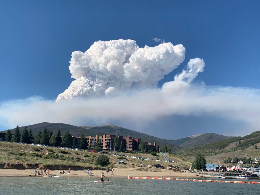
3:50 p.m. Firefighters expect this fire to grow as hot and windy conditions continue. CPR's Caitlyn Kim spotted the plume from the fire during a trip through the mountains.

8:42 a.m. This fire started on Friday and is burning in a remote part of the Williams Fork mountain range, but it has closed some campgrounds and county roads. More than 90 people are working to fight the fire.