A revised congressional redistricting map is out. And it looks very different from the earlier draft that had been circulating for months — and from the way the state is divided up now.
This version is a launching point for discussion by commissioners as they work toward a final map that most of them can agree on.
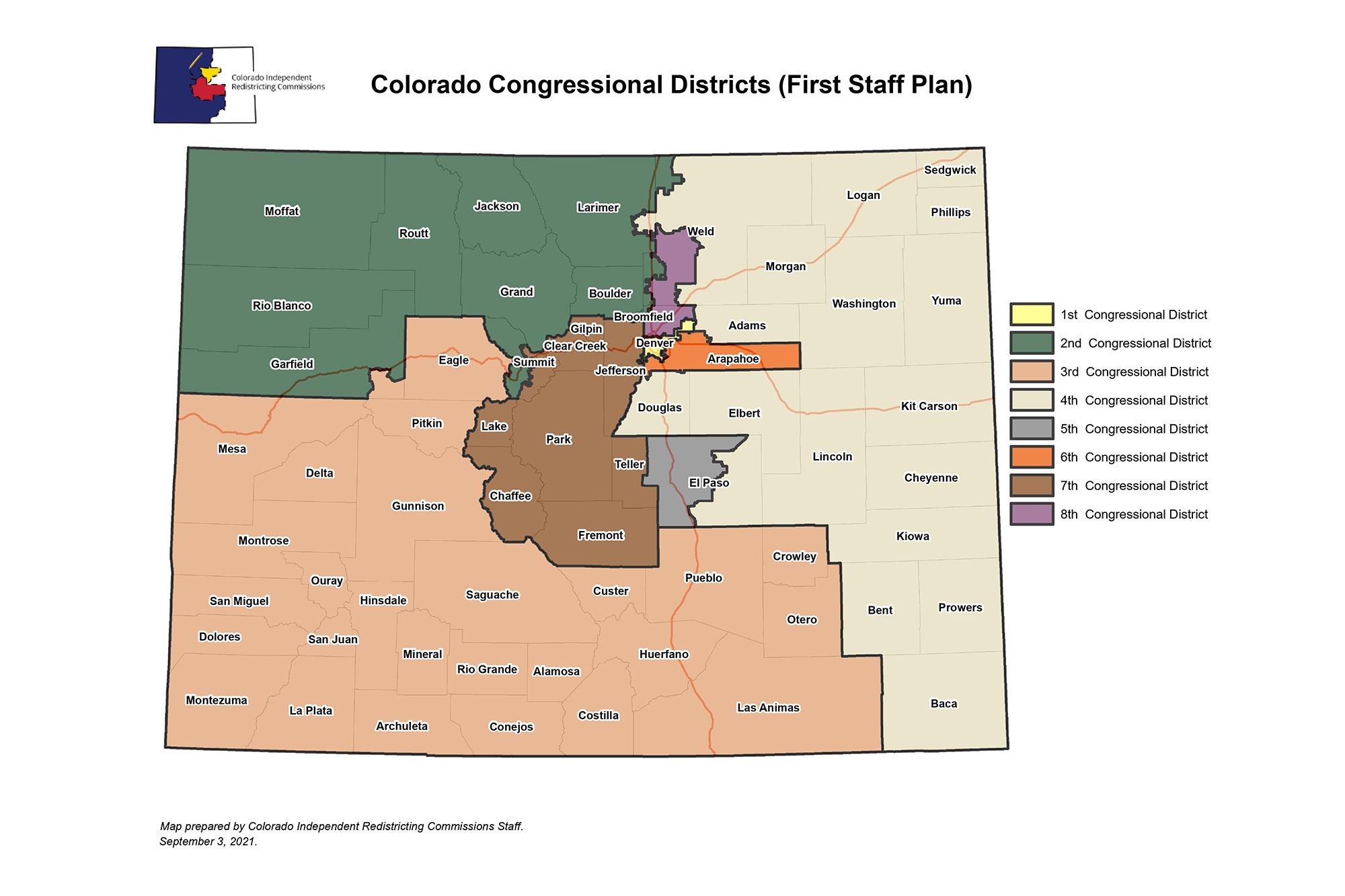
The biggest change is to the 3rd congressional district. Currently, it forms a massive hook encompassing the entire Western Slope and Pueblo. But the new staff map transforms it into a southern and western district that only reaches as far north as I-70, including Mesa and Eagle counties, and then stretches east past Pueblo to include Crowley, Otero and Las Animas counties.
This change means the Western Slope would be split into two districts, with the northern portion ending up in the 2nd congressional district. Under this configuration, the current third district Representative, Republican Lauren Boebert, who lives in Garfield County, would find herself drawn into CO-2. That potentially sets up a race between her and the CO-2 incumbent, Democrat Joe Neguse.
The state constitution specifically says commissioners can not try to protect the interests of current officeholders as they design the new map.
In a memo with the new proposal, the nonpartisan staff noted that the commission was divided on the idea of a largely southern district. However, a majority recommended that the map keep together the San Luis Valley, Pueblo and the Lower Arkansas Valley, and Souther Ute and Ute Mountain Ute tribal lands in the far southwest.
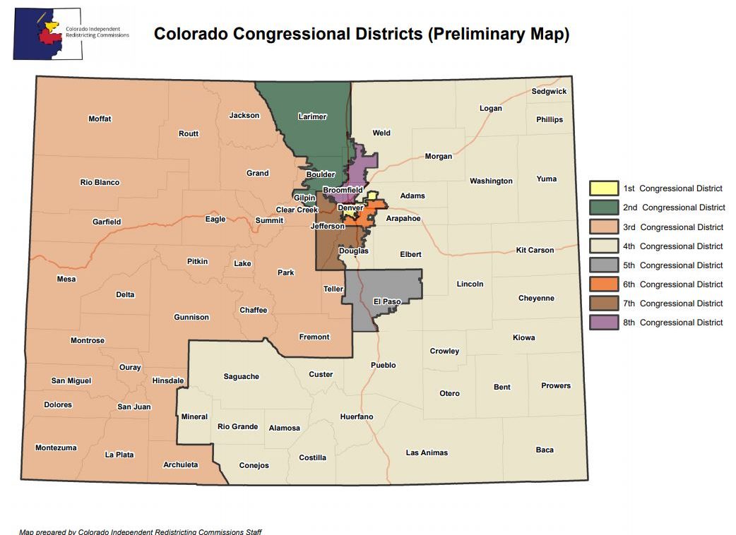
Take a look at the new proposed map, the first draft and what Colorado's districts look like right now.


One thing that does remain largely unchanged in this draft is Colorado’s newest congressional district, CO-8. It would remain in the north Denver metro — starting from Adams County and extending up mostly along the eastern side of I-25.
It does shed the metro north areas of Westminster, Broomfield and Arvada and instead would extend further north into Weld County, grabbing part of Greeley and Windsor. Losing bluer areas of the state and gaining redder ones could make it the state’s most competitive seat.
Reaction was swift
“For all of us geeks it’s been an exciting afternoon,” said Republican Frank McNulty, a former state House speaker and the registered agent of the Colorado Neighborhood Coalition, which has been advocating for congressional maps from a conservative perspective.
“The staff did the best they could with a recommendation they had to create a southern district,” McNulty said.
McNulty said it looked like the new Congressional map would create three safe Republican seats, three safe Democratic ones and two competitive districts. While he’s relatively pleased overall, McNulty said he considers some of the staff’s choices illogical, such as grouping Boulder with the northwest corner of the state.
“The idea of putting Northwest Colorado’s cattle ranchers with vegans in Boulder doesn’t make sense.”
Democratic political strategist Curtis Hubbard worked on the ballot measures that set up the commission and described the latest map as “pretty thoughtful.”
He said the map reflects a lot of what was discussed in the public hearings, from including a southern Colorado district to prioritizing Latino representation — the new CO-8 would be 38 percent Latino.
Theresa Trujillo is a Democratic community organizer in Pueblo and advocated for southern Colorado to be in one congressional district.
‘I’m, frankly, relieved the commissioners see this critical community of interest and have responded with a district that recognizes the unique nature of the Land Grant, Indigenous, and Native community in southern Colorado,” Trujillo said. “I’m also nervous that the commission has yet to get to eight votes.”
Not everyone is pleased with the map though
“Rural Colorado is the huge loser,” said Josh Penry, a Republican campaign operative who worked to pass the amendments that set up the new redistricting process. “I mean, rural Colorado got sliced and diced.”
However, Penry still thinks this map is “vastly preferable” than what would have come from the politicians who control the state Capitol. Under the old redistricting system, Democratic state lawmakers would have drawn the map this cycle.
Sara Blackhurst, CEO of Action 22, the advocacy group for 22 counties in southern Colorado, described the map as “fairly decent” but believes the variety within many districts will be a challenge for anyone who wants to represent them.
“If I were running for Congress, I would look at these maps and cry,” she said.
She pointed to CO-4, which would contain Castle Rock and Greeley, as well as counties in the southeast corner of the state.
“[The representative] is going to have to work really hard to make sure they remember that their representation is that far to the southeast.”
While Blackhurst is concerned about some elements of the southern district, she is happy that it would not include Colorado Springs.
“It’s dramatically different from what we originally hoped for. But this reflects that they genuinely listened to everybody,” she said.
The commission spent the summer gathering public input, holding more than 30 public hearings around the state and receiving tens of thousands of written comments.
Analysts poring over the map Friday night all had positive words for the work of the commission, and its staff.
“They’re in the middle of a massive, high-stakes tug-o-war. I think all of them deserve a lot of credit,” said Penry.
For anyone — especially Democrats — who might question the process, Penry has blunt words: “Those who have buyer’s remorse or those who want to question the will of the voters should take it up in therapy,” he said. After all, he notes, about 70 percent of voters supported the creation of the independent commissions in 2018.
Where things go from here
With the release of the new map, the redistricting process hits overdrive as the panel races to agree on a final plan and get it to the state Supreme Court no later than September 28.
Staff will formally present the map to the commission at a meeting on Monday (it’s a sign of how much time pressure they’re under that this government body is working on the federal Labor Day holiday). That will be followed by a lightning round of final remote public meetings — one for each Congressional district — before the panel gets down to really haggling over the final version.
And they still have a lot to sort out — from agreeing on the overall scope of changes, to deciding on the placement of individual neighborhoods.
Colorado’s constitution requires a supermajority vote to approve a final map, which means eight of the commission’s twelve members need to be on board. It also requires support from at least two commissioners who aren’t affiliated with either major political party.
If enough commissioners can’t rally around a map by the Sept. 28 deadline, a staff-drawn map will be submitted to the court instead.
The Colorado Supreme Court must approve the congressional redistricting map by Dec. 15.